


Where else do you want to go today?
Introduction
GPS used to be the preserve of the military. Now it's all over the place, and even in mobile phones. I've mentioned before that there are plenty stories in the news about people who just put all their faith in their GPS-powered devices and sacrifice their common sense and sense of direction to the great satellites in the sky.
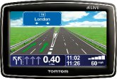
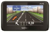
I've already covered the world of in-car satellite navigation with last year's review of the rather good TomTom XL IQ Routes. And earlier this year we started looking at personal navigation, with the Memory Map Adventurer 2800, a GPS for walkers, hikers, campers, ramblers and the like.
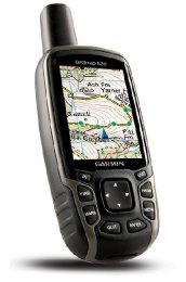
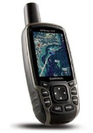
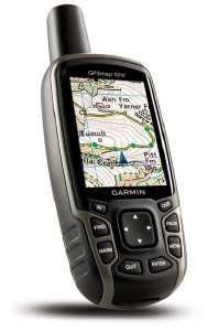
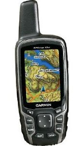
Today we take a look at the Garmin GPSMAP 62st. The replacement for the GPSMAP 60 series, this rugged and waterproof GPS "combines high-precision accuracy with high functionality to brave the demands of any terrain you dare to tackle".
It features a 2.6-inch sunlight-readable colour screen with built-in worldwide basemap with shaded relief and a quad helix antenna and high-sensitivity, WAAS/EGNOS-enabled GPS receiver with HotFix satellite prediction. You can also use additional mapping to improve your navigation experience.
You can store up to 2000 waypoints and 200 routes, and tailor the "dashboard" to show you the details you need. And (very importantly for us) the GPSMAP 62st supports Geocaching GPX files for downloading geocaches and their details straight to your unit. This means that you can do paperless caching which is very handy indeed. More on that story later.
Set Up
Take out of box. Insert batteries. Turn it on. Go somewhere.
To get the most out of your experience with this "mapping GPS" (one that supports downloading proper maps to show you where you are), you will probably want some mapping to help you on your way. You can buy a vast range of mapping from Garmin (with the 1:50,000 and 1:25,000 maps being the most popular). There is also a free map set that you can download which utilises the OpenStreetMap project. This gives you roads, street maps, and maps of footpaths. It's an open source project, so you might not want to rely on it completely, but the map set is being constantly improved by people getting out there and mapping paths etc. We've been out on walks with friends who've uploaded paths to it after our walks.
For more information on this:-
http://talkytoaster.info/ukmaps.htm
You can store some data on the internal memory and you can also use a MicroSD card for external storage. If you buy maps from Garmin they usually come pre-loaded on such a card. The whole of the UK at 1:50,000 fits on a 4Gb MicroSD card.
In Use
The only way to test these things is to get out there and go for some walks. Luckily, we do quite a lot of that, in fact we spend as much time as possible out walking (in between all that work stuff of course!) So we took it out on trips around the Peak District, a trip down to Kent (where we used the road navigation to help us get to a wedding), and for a week of walking in the New Forest.
What we normally do is to plan out various routes at home (we are long time users of Memory Map mapping software) and then take a little printed map (as well as a standard OS 1:25,000 map of the relevant area and compass) with us, along with printed pages for the caches that we are looking for, and then we use GPS to help out with finding the caches and navigating the route.
One of the big advantages of the latest range of GPS units from Garmin is that there's no need to take all the printed cache pages, since you can "go paperless". What this means is that the GPX/XML file that you can download to your PC from the Geocaching web site can then be uploaded to the GPS, and you can browse a couple of thousand web pages relating to those caches offline.
As with all other Garmin GPS devices, it tells you where you are, how far you've been, how far you've got to go, speed, average speed, current direction, time to the next stage/waypoint, the direction to travel in, etc. etc. You can customise the map view and the "trip computer" view to show you the fields you're interested in.
It locks on to your position (pretty quickly after start up too!) and being a mapping GPS, it shows you where you are on the map, and you can then read the map to work out what do to at the next junction of paths, or if you need to take the first un-signposted path on the left or the second one. Handily, it supports both north up (the map always points north) and track up (the map moves around with your direction of travel).
Having been out walking without a mapping GPS for years and years (until we bought our Memory Map Adventurer 2800 earlier this year), it really is a revelation to have one and be using it whilst out and about. It keeps track of where you are and where you want to go, with pretty good accuracy. Unlike the Memory Map Adventurer 2800, tree cover rarely causes the Garmin and problems, due to its excellent antenna and GPS receiver.
It is very easy to use for anyone who has ever used a Garmin GPS before, and even if you haven't it's all pretty logical and pretty easy to get started with.
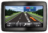
The other feature to mention is the on-road navigation. The 62st supports turn-by-turn navigation on roads, and can navigate you to your destination much like a TomTom. However, the disadvantage is that it doesn't talk to you, so you need somewhere to mount it in your car in order to read/interpret the directions (or someone to speak them to you!)
The one concern is the battery life when using "ordinary" AA batteries. They don't seem to last for much longer than a day or two, after which the unit goes into low power mode (stops alerting you when approaching waypoints). However, battery life is improved when using rechargeable batteries, so my advice would be to buy a set of four (at least) and always carry two spare batteries when out and about.
Conclusion
An excellent GPS, and a great companion for Geocaching.
It's not perfect, and there are some niggly little things that cause annoyance in use. Whilst many devices are turning to touch screen technology, this one continues in the Garmin tradition of navigating menus with a joystick/keypad combination. Whilst this usually works well, in certain screens, the joystick doesn't allow you to move a cursor around the screen, and instead you have to navigate to arrow icons to allow you to move the cursor. If you don't do much manual input of co-ordinates, you won't be that bothered, but if you do use this function, you might find yourself mumbling "grrrrrr..."
The other gripe is the karabiner (clip) that you use to attach it on to a bag/belt/etc. It's the wrong way round, so when you attach it to a shoulder strap of a rucksack the GPS is upside down and difficult to use. It's easy enough to detach it and use it, but sometimes it's nice to just have a quick glance without needing to remove it from your bag first.
As with all of these navigation systems, it's not a replacement for having a bit of an idea about where you're going, some basic map reading skills (combined with a compass, which should really be in your rucksack at all times), and a vague sense of where places are. But it should really help you out when you're off to the great outdoors.
The thing that might put you off is the price. Although the retail price is a whopping £399, you can pick the unit itself up for around £275, but that doesn't get you any mapping. You can use the free mapping mentioned earlier if you like, but some people would prefer real OS maps. For this you're looking at around £100 for a set of national parks at 1:25,000, and then about the same for other areas at this scale (e.g. Hadrians Wall, Peddar's Way, Norfolk Coast Path etc.) If you only reqiure 1:50,000 then you can pick up all the UK for around £200 (and some sites will bundle that in with the GPS for £400 all in). National parks at this scale are around £50, and you can buy Southern England and Wales, Scotland or Northern England and Midlands for around £100 each. Having used the Garmin 1:50,000 mapping, it is very good (identical to the paper version of course).
The best advice I can give is that if you think you'll want more mapping than just a certain area, save up to buy the biggest bundle you can. Buying bits at a time always costs you more.
Recommended for anyone who wants a quality mapping GPS. The OpenStreetMap maps might be the way to go to start off with, and if you can afford to invest in the Garmin maps you will find them very useful.
Your Opinions and Comments
Be the first to post a comment!