


Where do you want to go today?
Introduction
The satnav. It's everywhere. Using GPS technology to find your way around the country is de rigueur now. Everyone's doing it. And sometimes with disastrous/unexpected consequences that take a lorry through a quiet little cul-de-sac, or direct you to the edge of the cliff. There are plenty stories in the news about people who just put all their faith in these devices and sacrifice their common sense and sense of direction to the great satellite in the sky.
I've already covered the world of in-car satellite navigation with last year's review of the rather good TomTom XL IQ Routes.
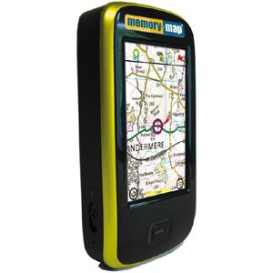
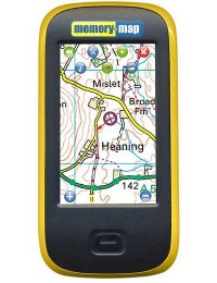
Today it's the world of personal navigation, with the Memory Map Adventurer 2800, a GPS for walkers, hikers, campers, ramblers and the like. Although it can also handle the in-car stuff too, with an optional add-on. More on that story later.
These devices are nothing new either. In fact, we've had a similar one for five years, and it's been out walking with us, tracking our movements and helping us find our way over a couple of thousand miles of British (and some further afield) terrain. And it's helped us to find over 1,000 geocaches in that time too. That device was (and still is) the Garmin eTrex Legend C. It was great. But it was not a "mapping" GPS. It has a basic base map, but nothing more than a representation of major roads. The rest (routes, waypoints, etc.) is up to you!
During the same period, we've made massive use of mapping software called Memory Map. It allows you to draw out routes, see your tracks, and mark points of interest (waypoints) on the map. You can then send the routes or waypoints to your GPS, or print out selected areas of the maps. You can print out sections of maps with your routes and waypoints on. And when you've been for a walk you can upload your track log to Memory Map and see where and how far you walked (useful for keeping track of what you've done if you've set yourself a challenge of walking 500 miles in a year for example - we've not managed it yet, totting up around 400-450 miles in each of the last 2 years).
With Memory Map, you can purchase various sections of map at 2 levels of detail. These are 1:50,000 (OS LandRanger, purple/pink maps) and 1:25,000 (OS Explorer, orange maps). The choice is entirely up to you, but the costs are different. The lower detail levels of the 1:50,000 maps will cost you less money. You can buy common areas such as national parks (Lakes, Peaks, Brecon Beacons, Cairngorms, etc.) or you can buy areas of your choosing "OS Selections". The latest versions of the software allow you to access a digital map shop to do all of this.
This background is important, because one of the main reasons that you might be buying this GPS is if you have already invested in Memory Map maps. It was a massive influence for us, as we have done just that, and to buy any other mapping GPS (SatMap Active or Garmin Oregon for example), would have required re-investing a lot of money in their additional mapping (to buy the Lake District at 1:25,000 for the Garmin would cost £129).
So it would seem Memory Map have worked out that their customers would like to buy a mapping GPS that uses Memory Map mapping, to make the most of their investment. So they made one.
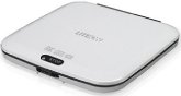
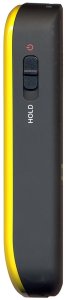
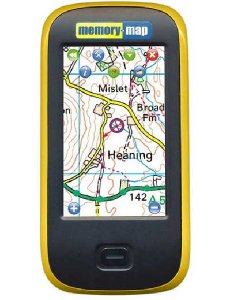
Essentially it's a WinCE PDA type device which just happens to specialise in running a mobile version of Memory Map. It has a 2.8" touchscreen which can be operated with fingers, gloved hands or an included stylus. Apparently, early test devices didn't have the stylus, and people expected one, so they added one that you can attach to the lanyard. We've been using our own, a combination pen/stylus, since we often need a pen when out and about walking.
Set Up
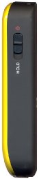
Take out of box. Charge up (via USB, standard wall socket or via in car charger). Turn it on. Go somewhere.
The Memory Map Adventurer 2800 comes with all of Britain's national parks pre-loaded at 1:50,000, so if you happen to be in (or visiting) one, you're ready to go.
If you've already got some Memory Map maps on your PC (say for your local area, or anywhere else) then you can easily transfer these to the Adventurer 2800 and be on your way. When you connect it to your PC (via USB and remembering to tap the screen to tell it to become a mass storage device), it appears as 2 additional drives, one for the internal memory, and one for the supplied 2Gb MicroSD card. You can transfer the maps to the card using Memory Map, and you're ready to go.
You can also transfer your Memory Map overlays (routes, tracks, waypoints, Geocaches, etc.) to the device by exporting them as a file (always a good idea to have an external back up of these, as it would be a real pain to lose them if you've done lots - we have!) If you do that then you have all your routes etc. that you've got on your PC ready to take out into the great wide open.
In Use
It's brilliant. It's not perfect (yet) but it is an excellent device.
The only way to test these things is to get out there and go for some walks. Luckily, we've just been walking in the Lakes for a week, the perfect place to test it out.
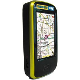
We did what we normally do, planning out various routes, taking a little printed map (as well as a larger back up map) with us, and using the GPS to help out. Only this time, we had the Adventurer 2800 with us too, so you can see exactly where you're walking on the map. Using the 1:25,000 Memory Map map of the Lakes that we've had for several years now, we could watch where we were going on the screen. As well as importing routes, you can make them up yourself on the Adventurer, using the screen and a finger or stylus. You can then tell it to follow those routes, and it displays information about your current direction, time to the next stage/waypoint, and the direction to travel in. And of course, it locks on to your position, so it shows you where you are on the map, and you can then read the map to work out what do to at the next junction of paths, or if you need to take the first un-signposted path on the left or the second one.
Having been out walking without a mapping GPS for years and years, it really is a revelation to have one and be using it whilst out and about. It keeps track of where you are and where you want to go, with pretty good accuracy. As usual with devices such as this, tree cover sometimes causes it to get a little confused, but not in such a way as to cause you a great deal of stress.
I found it really easy to use, probably due to a combination of being a long time Memory Map user (the mobile version of the software is very similar to the PC version, although not identical) and also being a bit of a techno person. There's a handy little "Get Started" guide inside the box, and the Memory Map web site contains FAQs and other useful information. Some new users have struggled with it a bit, but it just felt like second nature to me. And it's only 135g too, so it's certainly no burden.
The claimed battery life is around seven hours, although this will vary due to various factors such as:-
screen brightness
auto-dimming settings
exterior temperature
We had the Adventurer 2800 on for around 6-7 hours with screen brightness set just below halfway, and the screen set to "always on" (no dimming), whilst out walking in temperatures below freezing (down to around -5C), although the 2800 was kept in a pocket when not in use (which doesn't cause any problems with it knowing where you are). It never ran out of power on us.
I can't really fault its performance. That's not to say that there aren't things that could be improved (have already added some of them to the Wish List forum on the Memory Map web site), but it did just about everything that I could want from a mapping GPS.
Conclusion
Brilliant.
Like I said earlier, it's not yet perfect, and there are a few little niggles and things that you might want to see added. But for a mapping GPS that you can just use out of the box, it's pretty damn good. To get the most out of it, you'll probably need to spend a bit of time using it, or doing things with Memory Map on the PC and then exporting the overlay file to the Adventurer 2800. If you've already got other Memory Map maps on your computer, you can now use them outdoors too, by taking this along with you. It really is the obvious choice for Memory Map fans.
As with the in-car navigation systems, it's not a replacement for having a bit of an idea about where you're going, some basic map reading skills, and a vague sense of where places are. And if you're venturing off to places unknown, a map of the area and a compass should be in your rucksack at all times. But with this device, they might just stay there for emergencies only. We used it on 6 walks over the New Year period, and were impressed with it at every turn.
The one issue that might crop up in the summer will be related to the battery life. If it lasts for around 7 hours, that's probably not enough for one of our summer walks. But help is at hand. There will be an additional battery pack released shortly (around £30), which should double the battery life of the 2800. It looks a bit like similar things for the iPhone, in that it attaches around the outside of the exsiting device, and makes it a bit chunkier.
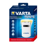
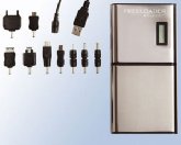
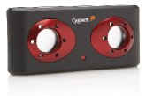
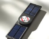
If that option's not for you then you could always invest in a portable USB charger like the Varta V-Man Power Pack or the FreeLoader Pro Solar Charger. These devices would recharge the 2800 whilst out and about (and the FreeLoader can then be recharged from the sun!) That's probably what we'll do come summer.
The only option that I can't comment on is the in-car SatNav option. This is available shortly (around £100 for a pre-loaded 4Gb microSD card) and covers all of Europe.
We've had it for two weeks. All we really want is more time to go walking and use it more!
Recommended for anyone who wants a good value mapping GPS, and particularly recommended if you have invested in Memory Map maps.
Your Opinions and Comments
Be the first to post a comment!